Google Maps micro-mobility

Planning a biking or scooting ride that is safe and fun with minimal effort.
Problem
Although the cycling industry is proliferating in the U.S., it is very difficult and cumbersome for people to plan routes that are suitable for biking and scooting, creating a decrease in safety and enjoyment for users. Google Maps is intended to be the single destination for transportation navigation, including micro-mobility. However, currently, there are too many gaps for people to use this as their primary navigation tool.
Objective
Integrate micro-mobility features into the existing Google Maps design system that allows users to effortlessly plan their cycling and scooting trips.
Discovery research
Research goals
Understand how micro-mobility fits into users’ lifestyles
Learn if there are triggering events that would cause users to need to plan a route and/ or use navigation while riding.
Determine what information users care about when selecting a route.
Determine what navigation information is needed while riding
Audit & Competitor analysis
I conducted an audit of Google maps as well as did competitor analysis for 3 alternate apps that people use to plan micro-mobility trips.
I found that Google Maps has a big advantage in its brand recognition but is severely lacking in features crucial to planning and navigating while on a scooter or bike. If Google Maps chooses not to fill these gaps, users may defect to another product that will. See the larger view of the comparison chart here.
User research study
I conducted seven 1:1 interviews with participants who had experience with biking or scooting in an urban environment. The main questions I was trying to answer with this study were:
What are the reasons that users choose to ride versus another means of transportation?
What would cause a user to need to plan a route or use navigation support while riding?
When and how do people choose a service to plan or navigate their rides?
What would make them choose to use this service and not another?
When did they ride in an unfamiliar environment? What was that like?
The study uncovered three major user problems with using Google Maps for micro-mobility trips:
Riding route recommendation not trustworthy
Unclear riding infrastructure data
Lack of traffic data from riding POV (both pedestrians and cars)
Research Synthesis
User Persona
User Point of View & How Might We?
Defining Solutions
Ideation
I conducted multiple rounds of ideation to uncover the best ideas that could solve the user problems identified. From there, I developed prioritization criteria to narrow in on the target solution.
Ideation Prioritization Matrix
Prioritization criteria
How deeply does this idea solve the core customer problem?
How much effort is this idea?
Feature Roadmap
IA & Interaction Design
User Flow
I created end-to-end user flow to make sure that I was thinking through all of the interactions for the key features.
Planning a micro-mobility trip
Sketches

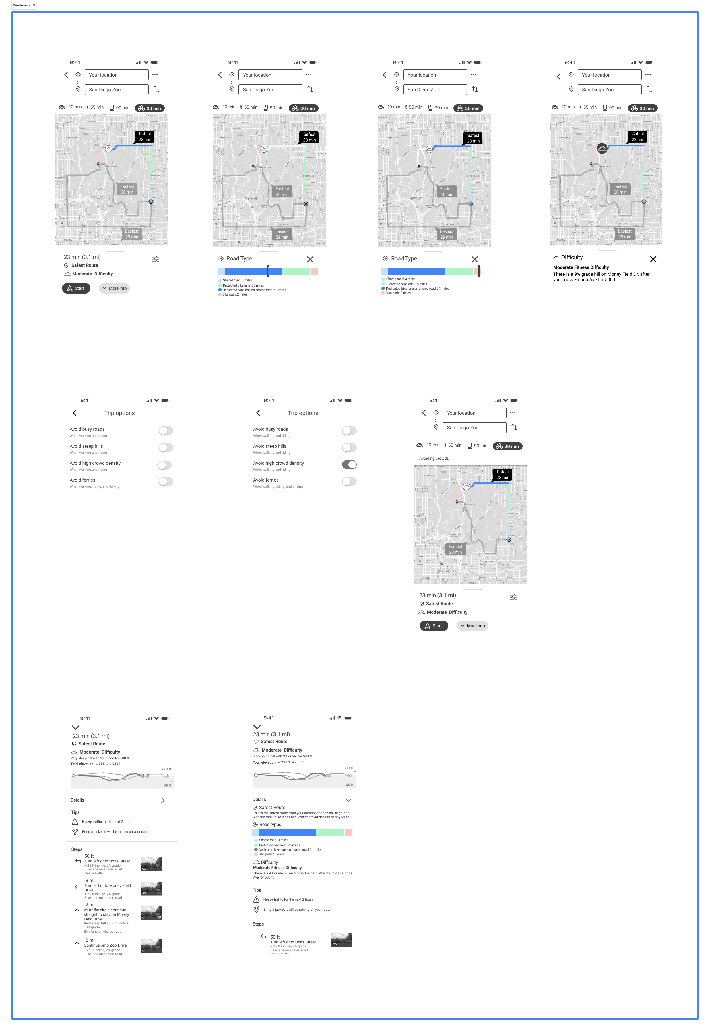
Wireframes
I digitized my sketches into wireframes, which brought them to life, and allowed me to get more detailed feedback on the interaction design from participants.